LEG 06 · Navigation & Weather
Why Is Flying East Faster Than Flying West?
Same airplane, same distance, different time. The difference is a river of fast wind several miles up.
Updated · 8 min read
The short answer
Flying east is usually faster because of the jet streams, narrow bands of strong wind several miles up that blow from west to east. An eastbound airliner can ride one as a tailwind, adding to its speed over the ground, while a westbound flight has to fight it or fly around it. Earth's rotation doesn't help directly.
Fly a round trip across the United States or the Atlantic and the two legs rarely take the same time. They cover the same distance, often on the same type of airplane, yet the westbound one usually takes longer. The airplane hasn’t changed. The air it flies through has.
Why is flying east faster than west?
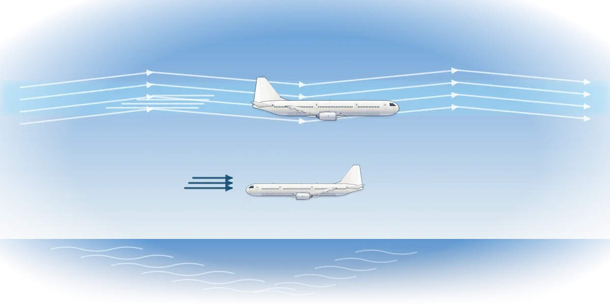
Because of the jet streams. These are bands of strong wind high in the atmosphere, and NOAA says Earth’s main jet streams blow from west to east. When an eastbound airplane joins one, the wind carries it along and its speed over the ground goes up. NOAA’s satellite service draws the conclusion for travelers: on any given route, the west-to-east trip is generally the quicker one.
Nothing about the airplane changes. It moves through the air at the same speed in both directions. What differs is how fast the air itself is moving over the ground, and the FAA’s handbook treats those as two separate motions that simply add together.
What is the jet stream?
A jet stream is a river of fast wind high in the sky, strongest at its core and slower toward its edges. NOAA’s National Weather Service says jet streams typically blow around 30,000 feet up and vary between four and eight miles in height. NOAA’s satellite service puts them a little higher, at about five to nine miles. Either way, that is right where airliners cruise.
On average a jet stream moves at about 110 mph, and when the contrast between warm and cold air is sharp it can top 250 mph, according to NOAA. The weather service says they can exceed 275 mph. The fastest winds usually come in the polar jet streams in winter.
Jet streams form where warm and cold air masses meet, and they follow that boundary as it moves. NOAA places the polar jet between 50 and 60 degrees of latitude and the subtropical jet near 30 degrees. Both meander north and south, sometimes split and can even vanish for a while, but their overall direction stays west to east.
How does the jet stream affect flight time?
The FAA’s handbook uses a simple example. An airplane flying east at 120 knots through still air covers 120 knots over the ground. Put it in a 20-knot wind from the west and it covers 140; turn the wind around and it makes only 100. Its airspeed never changes, only its ground speed.
Now scale that up. At Mach 0.85, inside the FAA’s cruise range for civil jets, an airliner at 40,000 feet is moving at about 560 mph through the air, as what is Mach 1? explains. Add a 110 mph tailwind, NOAA’s jet stream average, and it crosses the ground at about 670 mph. Into the same wind it makes about 450 mph: over 3,000 miles, that is roughly four and a half hours one way and well over six hours the other.
Real flights rarely get the full effect, because a meandering jet stream seldom lines up with a route from end to end. Planners also work around the wind, and the best path out is often not the best path back. Heading east, the FAA’s handbook says, the helpful winds are on the northern flank of a high-pressure system; heading back west, they are on its southern flank.
So the outbound and return flights between two cities often take different paths. NOAA says jet streams are strongest in winter, when the boundary between warm and cold air is sharpest. That is when the gap between eastbound and westbound times tends to be widest.
Does the Earth’s rotation affect flight time?
Not directly, though it is a natural guess. The Earth, its air and an airplane parked at the gate all turn together. NOAA notes that the ground at the equator, and the air above it, is carried east at more than 1,000 mph by the planet’s spin. An airplane that takes off is already moving with that air, so flying east or west neither borrows from the spin nor fights it.
What an airplane feels is wind, the movement of the air over the ground. The FAA’s handbook puts it neatly: inside a 70-knot gale, a pilot would notice nothing but the odd bump, and only the ground below would give the wind away.
The spin does matter in another way: it is the reason the jet streams blow east. NOAA explains that air moving toward the poles keeps the eastward speed it had nearer the equator, while the ground beneath it is moving east ever more slowly. The air runs ahead of the surface below it, and to anyone on the ground that is a wind from the west. So Earth’s rotation does help eastbound flights, but by shaping the wind, not by pushing the airplane.
Why do planes fly curved routes?
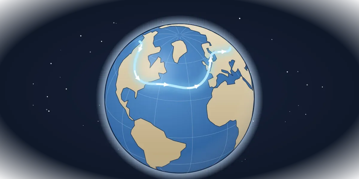
Because the Earth is round and most maps are flat. The FAA’s handbook calls the shortest path between two points on the Earth’s surface a great circle route, and on a flat map it rarely looks straight. Between two cities in the Northern Hemisphere, it bows toward the North Pole, which is why the line on a seat-back map seems to take a detour north.
Picture a string stretched tight between two cities on a globe. It does not follow the line of latitude that joins them, because that line is not the shortest way around a sphere. The string takes the more northerly path, and long-haul flights follow it as closely as the winds and the airspace allow.
A long route is a balance between the two ideas: the great circle is the shortest path, and the winds decide whether a longer one would be quicker. Over the oceans, flights are tracked and kept apart in a different way, as how air traffic control works explains.
How did planes navigate before GPS?
With landmarks, a compass, a clock and arithmetic. Pilotage means following features on the ground, such as rivers, roads and towns. Dead reckoning means working out position from heading, speed and time, and it works even over open water with nothing to look at.
The catch is the wind. The same moving air that speeds up eastbound airliners also slows airplanes down or pushes them sideways, so navigators have to correct for it. In one FAA example, an airplane heading east at 120 knots in a 20-knot wind from the north ends an hour’s flight 20 miles south of where its heading pointed.
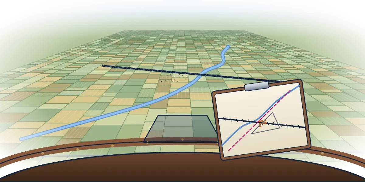
The magnetic compass is one of the oldest instruments in the cockpit. It points to magnetic north, which is not at the geographic North Pole, so charts show the difference, called variation. Radio came next: a VOR ground station sends out courses called radials in every direction, numbered from 001 to 360 by their magnetic bearing.
GPS, built by the US Department of Defense and opened to civilian use in the 1980s, now gives a position from a network of satellites. A receiver needs at least four of them to fix its position in three dimensions, including altitude.
The pioneers managed with far less. When four Douglas World Cruisers set out to fly around the world in 1924, they carried no radio and nothing more advanced than an earth inductor compass. Two of them completed the trip, after 175 days.
Fifteen years later, the Boeing 314 Clipper opened the first scheduled air service across the Atlantic, on June 28, 1939. It cruised at 184 mph, and for an airplane that slow, wind mattered even more. A 50 mph headwind would have cut its progress over the ground by more than a quarter.
Do you lose time flying east?
On the clock, yes, but not in the air. Because the Earth turns, local time runs ahead the farther east you go. Fly east and the clocks at your destination are ahead of the ones you left; fly west and they are behind. None of that changes how long the airplane spends in the air.
That is why an eastbound overnight flight can look so long on paper. Imagine a seven-hour flight that leaves at 7 p.m. and crosses five time zones heading east. It lands at 7 a.m. local time, twelve hours later by the clock, after only seven hours aloft. The westbound return might spend eight hours in the air against the wind, yet land just three hours after it left, by local time.
So two effects pull in opposite directions. The wind makes the eastbound flight shorter in the air, while the time zones make it look longer on the clock. Westbound, it is the other way around.
What to watch for on your next flight
- Ground speed on the moving map. Eastbound in a jet stream, it can climb well above the airliner’s speed through the air. Westbound, it can sink well below it.
- The route line. On a long flight it bends toward the pole, tracing something close to a great circle rather than the straight line a flat map suggests.
- A different path home. Compare the outbound and return routes on the map. They often differ, because each one is planned around the wind.
- Bumps in clear air. Near a jet stream the ride can turn rough with no cloud in sight, as is turbulence dangerous? explains.
- The arrival time. Eastbound, the local time at landing jumps well ahead of the hours actually flown. Westbound, it lags behind them.
Flying east is faster for a simple reason: for part of the way, the air itself is heading the same way. The high, cold air that carries those winds is also where airliners cruise and where contrails are born.
Quiz
Check yourself
-
Question 1 of 3
Why is flying east often quicker than the same trip west?
- Jet stream tailwinds push it along
- Earth's spin carries the plane
- Air is denser over the ocean
- Eastbound jets fly at lower altitudes
Show the answer
Answer: A. Flying with a jet stream gives an eastbound airplane a tailwind boost, shortening the trip compared with flying west.
-
Question 2 of 3
What does dead reckoning use to work out position?
- Satellite signals
- Landmarks on the ground
- Heading, speed and time
- Radio beacons
Show the answer
Answer: C. Dead reckoning calculates position from direction, speed and elapsed time, corrected for the effect of the wind.
-
Question 3 of 3
What is the angle between true north and magnetic north called in aviation?
- Variation
- Inclination
- Deviation
- Precession
Show the answer
Answer: A. Variation is the angle between true and magnetic north; deviation is a separate error caused by the airplane itself.
Guides
Keep reading
Navigation & Weather
Why Do Planes Fly at 35,000 Feet? Thin Air, Smooth Rides and Saved Fuel
Navigation & Weather
Is Turbulence Dangerous? What's Happening When the Plane Shakes
Navigation & Weather
What Are Contrails? Why Planes Leave White Trails
Airports & Air Traffic Control
How Does Air Traffic Control Work? From the Tower to the Ocean
Aircraft
From the Hangar
Sources
- NOAA Satellite and Information Service, What Is the Jet Stream?
- NOAA National Weather Service, The Jet Stream
- Federal Aviation Administration, Pilot's Handbook of Aeronautical Knowledge (FAA-H-8083-25C)
- Smithsonian National Air and Space Museum, The Story of the First Flight Around the World
- Boeing, Select Products in Boeing History